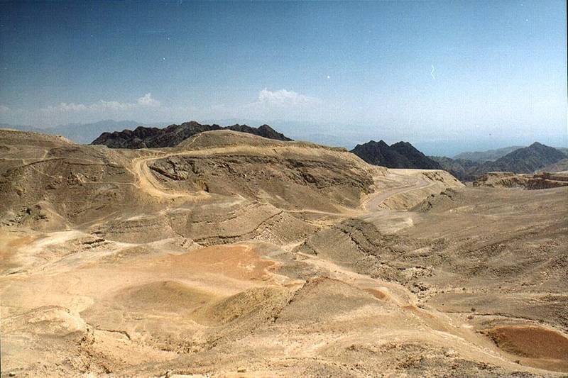
Area of Ihoram Mt. near Ma'ale Eilat Rd., 3 miles north-west from Eilat. The Middle East

🎞️ #192-17
▦ Current Album
Road 12 to Eilat - Mount Shelomo near Eilat, March 22, 2001

Album 192: Road 12 to Eilat - Mount Shelomo near Eilat, March 22, 2001

The image presents a desolate and arid landscape, characterized by vast expanses of dry earth and rock formations.

* **Terrain:**
* The terrain is predominantly barren, with sparse vegetation.
* Rocky outcrops are scattered throughout the area.
* Sand dunes cover parts of the land, indicating a semi-arid environment.
* **Sky:**
* Above, a clear blue sky dominates the scene.
* A few wispy clouds can be seen in the distance to the left side of the image.
* **Mountains:**
* In the background, mountain peaks rise above the horizon.
* These mountains are rugged and rocky, contributing to the harsh appearance of the landscape.

In summary, the image depicts a stark desert environment characterized by arid terrain, sparse vegetation, and distant mountain ranges under an otherwise clear blue sky. – AI vision

Similar Find pictures that are similar to this picture

Thumbnail of picture 192-18: Trenches on Ihoram Mt. near Ma ale Eilat Road, 3 miles north-west from Eilat. The Middle East, March 22, 2001 Similar(1): Trenches on Ihoram Mt. near Ma ale Eilat Road, 3 miles north-west from Eilat. The Middle East, March 22, 2001 Thumbnail of picture 192-20: Trenches on Ihoram Mt. near Ma ale Eilat Road, with Mount Shelomo on ... west from Eilat. The Middle East, March 22, 2001 Similar(2): Trenches on Ihoram Mt. near Ma ale Eilat Road, with Mount Shelomo on ... west from Eilat. The Middle East, March 22, 2001 Thumbnail of picture 192-06: A jeep road going to Netafim spring from Ma ale Eilat Road, 3 miles north-west from Eilat. The Middle East, March 22, 2001 Similar(3): A jeep road going to Netafim spring from Ma ale Eilat Road, 3 miles north-west from Eilat. The Middle East, March 22, 2001 Thumbnail of picture 192-05: A jeep road 1 mile south-east from Netafim Border Check Point from Ma ... west from Eilat. The Middle East, March 22, 2001 Similar(4): A jeep road 1 mile south-east from Netafim Border Check Point from Ma ... west from Eilat. The Middle East, March 22, 2001 Thumbnail of picture 192-26: A jeep track approaching Mount Shelomo from Ma ale Eilat Road, 3 miles north-west from Eilat. The Middle East, March 22, 2001 Similar(5): A jeep track approaching Mount Shelomo from Ma ale Eilat Road, 3 miles north-west from Eilat. The Middle East, March 22, 2001 Thumbnail of picture 192-23: A short creek with a trail to Mount Shelomo from Ma ale Eilat Road, 3 miles north-west from Eilat. The Middle East, March 22, 2001 Similar(6): A short creek with a trail to Mount Shelomo from Ma ale Eilat Road, 3 miles north-west from Eilat. The Middle East, March 22, 2001 Thumbnail of picture 193-14: Eilat and Aqaba, view to south-east from Mount Shelomo, 3 miles north-west from Eilat. The Middle East, March 22, 2001 Similar(7): Eilat and Aqaba, view to south-east from Mount Shelomo, 3 miles north-west from Eilat. The Middle East, March 22, 2001 Thumbnail of picture 193-08: View of northern Eilat and Aqaba from Mount Shelomo, 3 miles north-west from Eilat. The Middle East, March 22, 2001 Similar(8): View of northern Eilat and Aqaba from Mount Shelomo, 3 miles north-west from Eilat. The Middle East, March 22, 2001

Keywords & Related