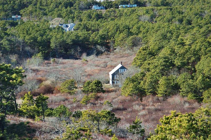
Abandoned cranberry bogs near North Pamet Rd. in Cape Cod. Truro, Massachusetts

🎞️ #371-10
▦ Current Album
Cape Cod - Newport RI, December 27, 2003 - January 1, 2004

Album 371: Cape Cod - Newport RI, December 27, 2003 - January 1, 2004

The photograph depicts a landscape of abandoned cranberry bogs on Cape Cod. The area is characterized by numerous small ponds scattered throughout, with some water visible in the foreground and background. These ponds are likely remnants of former cranberry bog farming operations.

In the middle ground, the image reveals an open field or wetland area that was once used for cranberry cultivation. The soil and vegetation have changed since the bogs were abandoned, indicating a shift in land use over time. Some of these areas may now be covered with trees or shrubs as nature reclaims the land.

In the background, three houses are visible on the ridge above the bogs. These residences suggest that the area is still being used for residential purposes, but their presence does not necessarily indicate active cranberry farming in the foreground.

Overall, this image captures a scene of transition and change in an agricultural landscape. The abandoned cranberry bogs provide a glimpse into the past use of the land, while the surrounding environment continues to evolve over time. – AI vision

🇨🇳 中文描述 / Chinese Description

位于密德伦路附近的卡普科德的遗弃蔓越莓沼泽。马萨诸塞州特鲁罗,2003年12月28日。照片描绘了卡普科德遗弃的蔓越莓沼泽地景观。这个区域以遍布小池塘而闻名,其中一些水体位于前景和背景中。这些池塘可能是之前种植蔓越莓的遗址。照片中间部分展示了曾用来种植蔓越莓的开阔田地或湿地,土壤和植被已经发生变化,表明土地使用方式在不断转变。这些区域中有一部分可能已被树木或灌木覆盖,因为大自然在吞没这片土地。照片背景处可见三栋房屋,位于沼泽上方的山脊上。这些房屋表明该区域仍被用作居住目的,但它们的存在并不一定表示前景中有活跃的蔓越莓种植业务。总体而言,此照片勾勒出一个农业景观转变和变化的场景。遗弃的蔓越莓沼泽提供了对土地过去用途的一瞥,周围环境也在不断演变。. – Chinese translation

Similar Find pictures that are similar to this picture

Thumbnail of picture 371-12: The Great Beach near the end of North Pamet Road in Cape Cod. Truro, Massachusetts, December 28, 2003 Similar(1): The Great Beach near the end of North Pamet Road in Cape Cod. Truro, Massachusetts, December 28, 2003 Thumbnail of picture 371-13: Moor, houses and a pond at the end of North Pamet Road in Cape Cod. Truro, Massachusetts, December 28, 2003 Similar(2): Moor, houses and a pond at the end of North Pamet Road in Cape Cod. Truro, Massachusetts, December 28, 2003 Thumbnail of picture 371-11: Moor and houses near Ballston Beach at the end of North Pamet Road in Cape Cod. Truro, Massachusetts, December 28, 2003 Similar(3): Moor and houses near Ballston Beach at the end of North Pamet Road in Cape Cod. Truro, Massachusetts, December 28, 2003 Thumbnail of picture 371-14: Entrance to Ballston Beach at the end of South Pamet Road in Cape Cod. Truro, Massachusetts, December 28, 2003 Similar(4): Entrance to Ballston Beach at the end of South Pamet Road in Cape Cod. Truro, Massachusetts, December 28, 2003 Thumbnail of picture 375-10: Houses and a frozen pond at the end of North Pamet Road in Cape Cod. Truro, Massachusetts, January 31, 2004 Similar(5): Houses and a frozen pond at the end of North Pamet Road in Cape Cod. Truro, Massachusetts, January 31, 2004 Thumbnail of picture 384-13: Cranberry bogs between dunes of Head of the Meadow Beach. Truro, Massachusetts, March 20, 2004 Similar(6): Cranberry bogs between dunes of Head of the Meadow Beach. Truro, Massachusetts, March 20, 2004 Thumbnail of picture 362-16: Holding pond behind cranberry bogs in the area of Perry Bogs of Massasoit State Park. East Taunton, Massachusetts, October 18, 2003 Similar(7): Holding pond behind cranberry bogs in the area of Perry Bogs of Massasoit State Park. East Taunton, Massachusetts, October 18, 2003 Thumbnail of picture 371-04: Highland (Cape Cod) Lighthouse. North Truro, Massachusetts, December 28, 2003 Similar(8): Highland (Cape Cod) Lighthouse. North Truro, Massachusetts, December 28, 2003

Keywords & Related