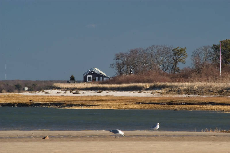
Salt Marsh east from north end of Bone Hill Rd. in Cape Cod. Barnstable, Massachusetts

🎞️ #427-15
▦ Current Album
Tiverton - Jamestown RI, December 8 - 18, 2004

Album 427: Tiverton - Jamestown RI, December 8 - 18, 2004

The photograph depicts a serene landscape of salt marshes on the eastern edge of Bone Hill Road in Cape Cod, Massachusetts. The scene is dominated by various shades of brown grasses and brush, which occupy most of the frame horizontally, from left to right.

In the background stands a small red house with white trim, situated on a hill above the marsh. To its left lies a dense forest, which extends beyond the horizon. Above the landscape, the sky is a brilliant blue, devoid of clouds or any other obstructions.

The foreground features three prominent subjects: two seagulls and what appears to be a small rock or log protruding from the mud of the marsh. The gulls are positioned in the lower right corner, with one facing towards the bottom-right edge of the image and the other facing away from it. In contrast, the rock is located slightly above them, directly below the house.

The overall atmosphere of the photograph exudes a sense of tranquility and isolation, capturing the beauty of nature in this unique location. – AI vision

🇨🇳 中文描述 / Chinese Description

马萨诸塞州布朗斯代尔的凯普科德岛,2004 年十二月十六日。这张照片描绘了马萨诸塞州凯普科德岛 Bone Hill Road 北端东侧的盐沼景色。该场景以各种颜色的棕色草和灌木为主导,它们横跨整个画面,从左到右占据大部分画面。画面背景是一座小红房子,其上方白线条明显,坐落于沼泽的山上,森林密集的背景则延伸至地平线之外。照片中天空清澈见蓝,没有云或任何遮挡物。最前方出现了三个主体:两只海鸥和一块从沼泽淤泥中突起的岩石或木头,这块岩石位于右下角,另一只海鸥正对准底部右侧边缘,而岩石则位于它们的上方,直接在小红房子的下面。整个照片散发出平静与孤独的气氛,展现了这个地区独特之处所蕴含的自然美景。. – Chinese translation

Similar Find pictures that are similar to this picture

Thumbnail of picture 427-16: Beach Point Light on Sandy Neck, view from north end of Bone Hill Road in Cape Cod. Barnstable, Massachusetts, December 16, 2004 Similar(1): Beach Point Light on Sandy Neck, view from north end of Bone Hill Road in Cape Cod. Barnstable, Massachusetts, December 16, 2004 Thumbnail of picture 435-25: Beach Point Light on Sandy Neck and frozen Barnstable Harbor, view ... Road in Cape Cod. Massachusetts, February 5, 2005. Similar(2): Beach Point Light on Sandy Neck and frozen Barnstable Harbor, view ... Road in Cape Cod. Massachusetts, February 5, 2005. Thumbnail of picture 390-07: A marsh in Bridge Creek Conservation Area in Cape Cod. Barnstable, Massachusetts, May 1, 2004 Similar(3): A marsh in Bridge Creek Conservation Area in Cape Cod. Barnstable, Massachusetts, May 1, 2004 Thumbnail of picture 414-16: Salt marsh and Long Point Lighthouse in Cape Cod. Provincetown, Massachusetts, September 25, 2004 Similar(4): Salt marsh and Long Point Lighthouse in Cape Cod. Provincetown, Massachusetts, September 25, 2004 Thumbnail of picture 421-01: A marsh creek and cordgrass east from Boardwalk Road in Cape Cod. Sandwich, Massachusetts, October 23, 2004 Similar(5): A marsh creek and cordgrass east from Boardwalk Road in Cape Cod. Sandwich, Massachusetts, October 23, 2004 Thumbnail of picture 390-06: Dunes of Sandy Neck in Cape Cod, view from Trail 1. Barnstable, Massachusetts, May 1, 2004 Similar(6): Dunes of Sandy Neck in Cape Cod, view from Trail 1. Barnstable, Massachusetts, May 1, 2004 Thumbnail of picture 390-08: Pollen(?) on surface of a pond in Bridge Creek Conservation Area in Cape Cod. Barnstable, Massachusetts, May 1, 2004 Similar(7): Pollen(?) on surface of a pond in Bridge Creek Conservation Area in Cape Cod. Barnstable, Massachusetts, May 1, 2004 Thumbnail of picture 379-06: Abandoned stone wall in a forest in Bridge Creek Conservation area in Cape Cod. Barnstable, Massachusetts, February 28, 2004 Similar(8): Abandoned stone wall in a forest in Bridge Creek Conservation area in Cape Cod. Barnstable, Massachusetts, February 28, 2004

Keywords & Related