
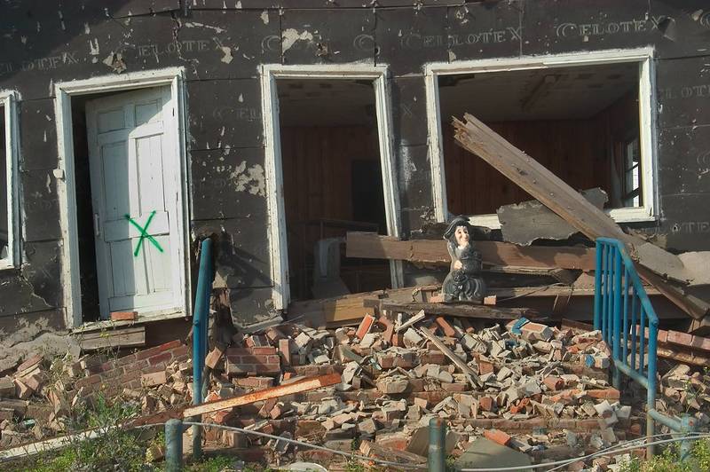

A house at Rd. 23 in Buras. Plaquemines Parish, Louisiana


Album 516: New Orleans - Plaquemines Parish, April 13 - 15, 2006
The image depicts a severely damaged house located on Road 23 in Buras, Plaquemines Parish, Louisiana. The photograph captures the aftermath of Hurricane Katrina's devastating impact on the area.
**Building Structure and Damage:**
* The two-story building is constructed from brick, with dark gray or black stucco covering its exterior.
* Windows are missing, and the door appears to have been torn off its hinges.
* A large portion of the roof has collapsed, with debris scattered throughout the yard.
**Debris and Surroundings:**
* A pile of rubble lies in front of the house, comprising broken bricks, shattered glass, and other debris.
* The surrounding area is littered with smaller pieces of debris, including a blue railing that appears to have been blown off the porch.
**Historical Context and Significance:**
* Hurricane Katrina made landfall on August 29, 2005, causing widespread destruction along the Gulf Coast.
* This image provides a poignant glimpse into the devastation caused by the storm in Buras, Louisiana, highlighting the significant impact it had on the local community.
**Conclusion:**
The image serves as a powerful reminder of the destructive force of Hurricane Katrina and its lasting effects on the people and places affected by the disaster. – AI vision
🇫🇷 Description en français / French Description
Une maison de la route 23 à Buras, Plaquemines Parish, Louisiane, le 15 avril 2006. L'image montre une maison gravement endommagée située sur la route 23 à Buras, Plaquemines Parish, en Louisiane. La photographie capture les conséquences dévastatrices de l'ouragan Katrina dans la région.
Structure du bâtiment et dommages : * Le bâtiment de deux étages est construit en briques, avec un stuc gris foncé ou noir recouvrant son extérieur. * Des fenêtres sont manquantes, et la porte semble avoir été arrachée de ses charnières. * Une grande partie du toit s'est effondrée, avec des débris dispersés dans toute la cour.
Débris et environs : * Un tas de gravats se trouve devant la maison, composé de briques cassées, de verre brisé et d'autres débris. * La zone environnante est parsemée de morceaux plus petits de débris, y compris une rambarde bleue qui semble avoir été emportée par le vent depuis le porche.
Contexte historique et importance : * L'ouragan Katrina a atteint la côte le 29 août 2005, causant des dégâts considérables le long de la côte du golfe. * Cette image donne un aperçu poignant des dégâts causés par la tempête à Buras, en Louisiane, soulignant l'impact significatif sur la communauté locale.
Conclusion : L'image sert de puissant rappel de la force destructrice de l'ouragan Katrina et de ses effets durables sur les personnes et les endroits touchés par la catastrophe. – French translation


