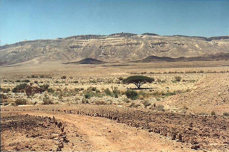
A jeep road at the bottom of Ramon Crater approaching Nahal Ramon River, view to the north, with Mitzpe Ramon Visitor's Center on horizon in the center (there is only one acacia tree in Ramon Crater in this area), 3 miles south-east from Mitzpe Ramon. The Middle East

🎞️ #205-36
▦ Current Album
Ramon Crater, May 3, 2001

Album 205: Ramon Crater, May 3, 2001

This photograph presents a desolate landscape with a jeep road winding its way into the distance towards Nahal Ramon River, set against a vast expanse of arid terrain and a clear blue sky.

The scene is dominated by an endless stretch of dry earth, punctuated by sparse vegetation that includes small green shrubs and trees. The road itself appears to be made of dirt or gravel and features several ruts and divots, suggesting it has been used extensively for vehicular travel. To the left of the image, a large boulder stands out against the otherwise barren terrain.

In the background, a series of rocky ridges rise up from the desert floor, with Ramon Crater's rim visible in the distance on the horizon, to the right of the road and above the middle of the photograph. The crater's rim is characterized by steep cliffs that drop precipitously into the valley below.

A lone acacia tree can be seen growing near the visitor center at Mitzpe Ramon, which is situated atop the rim of the crater on the horizon in the center of the image, approximately three miles south-east from its location. The sky above is a brilliant blue, with only a few small white clouds scattered across it.

Overall, this photograph captures a striking landscape characterized by rugged terrain and sparse vegetation, set against a dramatic backdrop of rocky cliffs and a vast expanse of desert. – AI vision

Similar Find pictures that are similar to this picture

Thumbnail of picture 205-37: View of Ramon s Tooth from distance of 4 miles on the opposite side of ... to decrease haze. The Middle East, May 3, 2001 Similar(1): View of Ramon s Tooth from distance of 4 miles on the opposite side of ... to decrease haze. The Middle East, May 3, 2001 Thumbnail of picture 174-28: A dry river on a bottom of Ramon Crater. Mitzpe Ramon Visitor Center ... to the north. The Middle East, February 1, 2001 Similar(2): A dry river on a bottom of Ramon Crater. Mitzpe Ramon Visitor Center ... to the north. The Middle East, February 1, 2001 Thumbnail of picture 205-38: View of hills at the bottom of Ramon Crater from distance of 1 mile to ... Visitor s Center. The Middle East, May 3, 2001 Similar(3): View of hills at the bottom of Ramon Crater from distance of 1 mile to ... Visitor s Center. The Middle East, May 3, 2001 Thumbnail of picture 174-31: A foot of a hill on a bottom of Ramon Crater. Mitzpe Ramon Visitor ... to the north. The Middle East, February 1, 2001 Similar(4): A foot of a hill on a bottom of Ramon Crater. Mitzpe Ramon Visitor ... to the north. The Middle East, February 1, 2001 Thumbnail of picture 175-11: Stone terraces on the bottom of Ramon Crater, down from the Visitor Center. Mitzpe Ramon, the Middle East, February 1, 2001 Similar(5): Stone terraces on the bottom of Ramon Crater, down from the Visitor Center. Mitzpe Ramon, the Middle East, February 1, 2001 Thumbnail of picture 173-36: View of Ramon Crater to south-west from a lookout near Visitor Center. Mitzpe Ramon, the Middle East, February 1, 2001 Similar(6): View of Ramon Crater to south-west from a lookout near Visitor Center. Mitzpe Ramon, the Middle East, February 1, 2001 Thumbnail of picture 173-34: View of Ramon Crater to north-east from a lookout near Visitor Center ... Mitzpe Ramon, the Middle East, February 1, 2001 Similar(7): View of Ramon Crater to north-east from a lookout near Visitor Center ... Mitzpe Ramon, the Middle East, February 1, 2001 Thumbnail of picture 204-32: A big tributary of Nahal Nekarot River and Ramon s Tooth (black hill ... from Mitzpe Ramon. The Middle East, May 3, 2001 Similar(8): A big tributary of Nahal Nekarot River and Ramon s Tooth (black hill ... from Mitzpe Ramon. The Middle East, May 3, 2001

Keywords & Related