
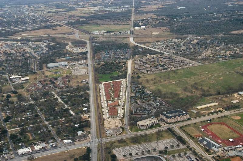

Area of Spear, with Southern Pacific Railroad and Wellborn Rd. to the left, Old Railroad Grade (Marion Pugh Dr.) to the right, George Bush Dr. and Rodeo Ground on the bottom, view from a window of a plane. College Station, Texas


Album 610: Guadalupe Mountains TX - Snowbird UT, December 28, 2007 - January 9, 2008
The image depicts an aerial view of the cityscape surrounding the area known as "Spear" in College Station, Texas. The photograph was taken on January 8, 2008, from a plane window and displays a bird's-eye perspective of the intersection between two highways, with a railroad track running through it.
From left to right in this image, one can see:
* **Southern Pacific Railroad**: A major railway line that runs parallel to the city streets.
* **Wellborn Road**: The road leading up to the intersection from the top-left corner of the image. Wellborn Road connects College Station to Bryan and is a main thoroughfare into the city's center.
At the bottom of this image, we can see:
* **Rodeo Grounds**: An open space where rodeos are held.
* **George Bush Drive (University Drive)**: This road runs vertically through the middle of the image. It connects College Station to Bryan and is a major road for traveling into the city's center.
On the right side of this aerial view, we see:
* **Marion Pugh Drive**: An alternative name given to Old Railroad Grade, which was originally known as Old Railroad Grade. This street is situated on top of an old railroad grade and runs vertically in a straight line through the middle of the image.
* **The area formerly known as "Spear" (now known as the Texas A&M University Research Park)**: Located at the intersection of George Bush Drive and Wellborn Road, this area is now home to various research facilities.
In summary, this image provides an aerial view of College Station's cityscape from a plane window. The image includes several key locations such as Southern Pacific Railroad, Wellborn Road, Rodeo Grounds, George Bush Drive (University Drive), Marion Pugh Drive, and the area formerly known as "Spear" which has since been renamed to the Texas A&M University Research Park. – AI vision
🇪🇸 Descripción en español / Spanish Description
Un área de Spear, con el ferrocarril del Pacífico Sur y Wellborn Road a la izquierda, el antiguo nivel del ferrocarril (Marion Pugh Drive) a la derecha, George Bush Drive y campo de rodeo en la parte inferior, vista desde una ventana de un avión. College Station, Texas, 8 de enero de 2008. La imagen representa una vista aérea del paisaje urbano que rodea el área conocida como "Spear" en College Station, Texas. La fotografía se tomó el 8 de enero de 2008 desde la ventana de un avión y muestra una perspectiva de ojo de pájaro de la intersección entre dos autopistas, con una vía férrea que discurre a su través. De izquierda a derecha en esta imagen se pueden ver: * **Ferrocarril del Pacífico Sur**: Una importante línea ferroviaria que discurre paralela a las calles de la ciudad. * **Wellborn Road**: La carretera que conduce hasta la intersección desde la esquina superior izquierda de la imagen. Wellborn Road conecta College Station con Bryan y es una vía principal hacia el centro de la ciudad. En la parte inferior de esta imagen, podemos ver: * **Campo de rodeos**: Un espacio abierto donde se celebran los rodeos. * **George Bush Drive (University Drive)**: Esta carretera discurre verticalmente por el medio de la imagen. Conecta College Station con Bryan y es una vía importante para viajar hacia el centro de la ciudad. En el lado derecho de esta vista aérea, vemos: * **Marion Pugh Drive (un nombre alternativo dado al antiguo nivel del ferrocarril): Una calle situada encima de un antiguo nivel del ferrocarril y discurre en línea recta y verticalmente por la mitad de la imagen. * **El área anteriormente conocida como "Spear" (ahora conocido como el Parque de Investigación de la Universidad A&M)**: Ubicado en la intersección de George Bush Drive y Wellborn Road, esta área ahora alberga varias instalaciones de investigación. En resumen, esta imagen proporciona una vista aérea del paisaje urbano de College Station desde la ventana de un avión. La imagen incluye varios lugares clave como Southern Pacific Railroad, Wellborn Road, campo de rodeos, George Bush Drive (University Drive), Marion Pugh Drive y el área anteriormente conocida como "Spear" que ahora se ha renombrado al Parque de Investigación de la Universidad A&M. – Spanish translation


